Advances in Direction Finding and Geolocation
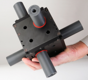
QUASAR Federal Systems has developed a family of compact electromagnetic vector sensors for direction finding and geolocation of Radio Frequency (RF) signals. Three of the sensors are shown below. At the left is our High Frequency (HF) model, in the center is the VHF sensor, and at right is the UHF sensor. These sensors are especially suited to airborne applications where size and weight are a priority.
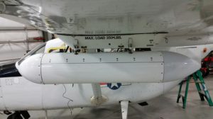
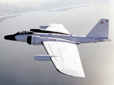
We recently conducted a flight test for which a sensor and its associated electronics were integrated into a pod that was mounted on an aircraft under the wing. This test was of single platform measurements; no other measurements were taken to enable location of the signal.
We successfully demonstrated:
- Rapid geolocation from a single airborne platform
- Ability to perform geolocation of an RF emitted while flying directly towards it
- Geolocation of short duration, low power transmissions
- Ability to geolocate a moving target
An RF emitter was set up on the ground and the plane flew orbits at a height of about 10,000 feet between 15 and 40 km from the emitter. Multiple readings were taken during this test. Some typical results are represented in the image below – the red x is the emitter, the circle represents the error the customer said would be acceptable (a circle of radius 3 km), the green lines show the direction determined from the plane to the emitter, and the green circles show the emitter location as calculated by the system in real-time. The yellow line shows the plane’s track and the yellow dot is a distance marker 20 km from the emitter.
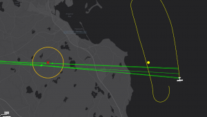
As you can easily see, the locations determined by the system fit well into the customer’s limits for error. This is unprecedented instantaneous geolocation accuracy from a single platform.
Please contact us if you’d like further information about our geolocation capabilities!
New Website Launch
QUASAR Federal Systems is pleased to launch its revamped website. A lot has changed for us since we launched our first site in 2005 and we are happy to have a new platform now to tell everyone about it.
Some of our most notable work in the past decade has been in airborne EM sensing for direction finding and geolocation. QFS has achieved some world firsts since the initial flight test of our 6-axis EM sensing devices in the nosecone of a large plane in 2005, creating ever more compact systems for small aircraft and extending their operating bandwidths for various applications.
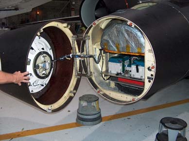
After the successful nosecone test, we began building a series of sensing pods for mounting on aircraft. A number of these devices have been constructed and flown on various aircraft around the US.
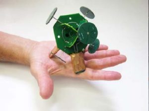
Today we’re building some much smaller devices. A six-axis device (3 axes of electric field and 3 of magnetic field) built recently is shown below. This is the heart of a design for a small UAV-mounted system that can both direction find and provide single-measurement geolocation capabilities.

In addition to airborne signal acquisition work, QFS instrumented a UAV with electric potential sensors for DARPA’s NIMBUS program. The goal of our effort was to fly the craft into thunderstorms to take measurements of lightning processes in thunderclouds for atmospheric research.
We have also been doing some interesting work in E-field based bullet detection, underwater E-field sensing, LF/VLF sensing for location applications, tunnel detection and many others.
With the launch of this site, QFS is kicking off a larger effort to stay in touch with our customers. Please connect with us on LinkedIn to get our announcements!